High resolution map shows extent of forest loss

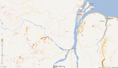
The highest resolution forest loss map to date is today published in the journal Science. The global map includes deforestation across the world including Guyana since 2000, at a resolution of 30m. The collaboration between the University of Maryland, NASA and Google Inc is the first of its kind, and the data will be freely available from January 2014.

See the interactive map here: http://earthenginepartners.appspot.com/science-2013-global-forest

Source: Hansen, M.C., Potapov, P.V., Moore, R., Hancher, M., Turubanova, S.A., Tyukavina, A., Thau, D., Stehman, S.V., Goetz, S.J., Loveland, T.R., Kommareddy, A., Egorov, A., Chini, L., Justice, C.O. & Townshend, J.R.G. (2013) High-resolution global maps of 21st-century forest cover change. Science, 342, 850-853.

defor4

New insights into Arapaima diet in Guyana

A new study published in the scientific journal, Neotropical Ichthyology uncovers the secret diet of the Arapaima. Contrary to many expectations, the research shows that Arapaima are not in fact top predators, feeding mainly as secondary consumers, and with a quite varied diet.

Read more…

Arapaima4

Indigenous People send message to UN on International Day of Forest

Under the COBRA (Community Owned Best practice for sustainable Resource Adaptive management in the Guiana Shield, South America) project, communities of the North Rupununi have made a video highlighting the importance of their forests for their livelihoods. The film which was produced, written an edited by the community members demonstrates the excellent work of project COBRA.

Watch the film